|
December 5th is recognized as World Soils Day. Iowa, perhaps more than any other state, owes its agricultural heritage and economy to some of the most fertile topsoil in the world. The dominant soil order across the region is called Mollisols (dark green in the below map). Mollisols are grassland soils that developed over centuries or millennia within prairie ecosystems.  Within the order of Mollisols, Udolls (green in the map below) are the predominant suborder:  Udolls align closely with the tallgrass prairie region, while Ustolls (another suborder of Mollisols) dominate the mixed- and short-grass prairies:  More than 99.9% of Iowa's tallgrass prairies have been destroyed by human development, and largely replaced with corn. Corn is a plant within the grass family, and like the many types of native grasses, it is well-adapted to thrive in the Udoll soils. The former tallgrass prairie is now aligned closely with the Corn Belt:  Iowa is divided into several soil regions (map below). In western Iowa, you've probably heard the term "loess" before. Besides the Missouri River Alluvium (14), which is floodplain soil on the flat bottoms of the Muddy Mo, most of the region is covered in a layer of loess. East of the alluvial plain are Missouri River Bluffs (13) and Very Deep Loess (12), which includes the Loess Hills landform. The Loess Hills are typically defined as having at least 60 feet of loess, though many of the bluffs adjacent to the Missouri floodplain are much deeper than that, even up to 200 feet deep. Learn more about the Loess Hills here. Loess was deposited through aeolian processes (wind-driven), with prevailing westerly winds dropping the deepest soils closer to the Missouri River. Moving east, the depth of loess gradually decreases over southern Iowa. The Des Moines lobe was glaciated more recently and lacks this loess.  The depth of loess aligns closely with the EPA-designated ecoregions of Iowa. 47d (Missouri Alluvial Plain) is the same as soil region 14 above. Ecoregions 47m (Western Loess Hills) and 47e (Steeply Rolling Loess Prairies) are similar to soil regions 11 & 12.  In the map below, purple areas have Peoria Loess, and green areas are alluvial soils. Most of western Iowa is either purple or green. The Des Moines lobe stands out as not having loess deposits.  Loess is highly erodible. The maps below from USDA show how the deep loess soils of Iowa, along with the loess region of the Palouse in eastern Washington, have some of the worst soil erosion on the continent. Fortunately, however, conservation practices like terraces and grassed waterways have significantly reduced this erosion over the past 40 years.  While many people think of soil as just dirt, there are complex ecosystems living within it. “Essentially, all life depends upon the soil… There can be no life without soil and no soil without life; they have evolved together” - Dr. Charles E Kellogg, Soil Scientist and Chief of the USDA’s Bureau for Chemistry and Soils. Even if you don't farm or garden, the food you eat on a daily basis depends on healthy soils. If soil is treated "like dirt," these webs suffer and soil health declines.  Our agricultural economy, waterways, and wildlife also depend on soils to thrive. Historically, poor soil health has contributed to the collapse of entire civilizations. This is why President Franklin Delano Roosevelt said, “The nation that destroys its soil, destroys itself" following the Dust Bowl. Soil health is becoming increasingly important in agricultural discussions and we should not overlook the humble humus beneath our feet. 
1 Comment
In September and October, Golden Hills had funding from The Gilchrist Foundation to continue our Prairie Seed Harvest project in the Loess Hills. We also have funding from Pottawattamie Conservation Foundation to do prairie seed harvest at Hitchcock Nature Center specifically. At each event, Project Coordinator Lance Brisbois provided a brief training on identifying species and ripe seed, then showed how to harvest the seed. Events Summary:
Through these events, we engaged more than nearly 100 volunteers of all ages totaling approximately 187 volunteer hours, worth well over $5,000 of time that would have otherwise been incurred by local conservation agencies with limited time and budgets. The seed we harvested was combined with seed purchased from other sources to be used on prairie restoration projects totaling several hundred acres. All seed collected from state lands was donated to Iowa Department of Natural Resources staff per state regulations. Most seed collected from other areas was given back to local conservation agencies for their prairie restoration efforts. Golden Hills saved a small amount of seed (with written permission) from land owned by county conservation boards for native plant propagation in partnership with Iowa Western Community College. We will grow some of this seed in their greenhouse over the winter and host a native plant sale in spring 2022. Some of the seed has also been saved by Golden Hills to start a small native seed bank. This seed will be stored long-term and added to each year, with the intent of growing a seed bank of local ecotype native species. We thank all the volunteers who helped this year, and look forward to hosting more seed harvest events in 2022. Thank you to The Gilchrist Foundation and Pottawattamie Conservation Foundation for their financial support. As part of this year's Giving Tuesday (November 30), we have a goal of 40 donors and $4,000 to support our Prairie Seed Harvest project. Learn more and donate here.                  The Iowa Tourism Economic Impact Report was recently released, and it shows that even through the pandemic, tourism has been a major contributor to the state's economy. "The results of this study show the scope of the travel sector in terms of direct visitor spending, as well as the total economic impacts, jobs, and fiscal (tax) impacts in the broader economy." Even with a 29% drop in 2020, tourists' direct contribution to Iowa's economy was $4.6 Billion. Because international travel was restricted and many people did not feel safe flying, more people chose to road trip closer to home. The pandemic also caused many people to choose more outdoorsy destinations and rural areas where they could easily distance, instead of more crowded cities and larger or indoor tourist attractions. In western Iowa, this has largely been beneficial since most of the communities are rural with abundant parks, trails, wildlife areas, and small towns & businesses. Tourism is especially impactful along Iowa's Scenic Byways. Loess Hills National Scenic Byway runs through the 7 Loess Hills counties from Plymouth to Fremont. Western Skies Scenic Byway, which crosses the region west-to-east from Harrison to Guthrie counties, is a popular alternate route to Interstate 80 between Omaha and Des Moines. Glacial Trail Scenic Byway is a short loop that runs through Buena Vista, Cherokee, Clay, and O'Brien counties in northwest Iowa along the Little Sioux River valley. Data for these Byway counties from the tourism report is summarized below.  Note that Harrison County is included on both Loess Hills and Western Skies, as both byways run through the county. Not all of the economic impacts are directly from Byway travelers only, but the counties are considered part of the Byway Corridors and thus the data include significant overlap. Golden Hills is proud to coordinate these three byways and all that they contribute to the region.   View along Preparation Canyon Loop of Loess Hills National Scenic Byway in Harrison County Broken Kettle Grasslands, owned and managed by The Nature Conservancy (TNC) in Iowa, recently held their annual bison roundup. Partners and volunteers from throughout the region helped round the bison up to check the health of the animals, weight them, and vaccinate them before releasing them back onto the prairie. Bison were, for thousands of years, an integral component of prairie ecosystems. TNC reintroduced bison to help control invasive species and improve prairie habitat. Broken Kettle, north of Sioux City along Loess Hills National Scenic Byway in Plymouth County, includes the largest remnant prairie and largest roadless area in Iowa. This area is the only known site with a population of prairie rattlesnakes in the state. The bison at Broken Kettle came from Wind Cave National Park and are called genetically pure since they have no cattle ancestry like most other bison found in the country today. The herd totals more than 200 and they spend the rest of the year roaming approximately 1,900 of the preserve’s 3,000 acres.  Rounded-up bison  Scott Moats with The Nature Conservancy observes a bull bison during the roundup  Bison getting weighed and health checkup  Bison corral during the roundup by Seth Brooks Fall is the best time to hike in the Loess Hills: temperatures are cool, humidity is low, insects are largely gone, and a mosaic of red, yellow, and brown paint the hillsides. According to the Iowa DNR, this week the southern Loess Hills should reach peak color. The forecast for the last weekend of October looks perfect for a leaf-peeping hike on any of the publicly accessible lands in southwestern Iowa. While the wind and rain that swept across Nebraska and Iowa this week will have knocked off some leaves, the precipitation could give rise to another wonder of fall: mushrooms! It will be difficult to keep your eyes on the colorful canopy when fantastic fungi are fruiting from the forest floor. Put on a jacket, grab your hiking boots, bring a basket, and go hiking this weekend! Waubonsie State Park, named for Chief Waubonsie of the Pottawattamie tribe, is perhaps the best place to soak in the fall forest atmosphere. The park, one hour south of Omaha just off Interstate 29, is divided into two sections divided by Highway 2. The northern section has multi-use trails and is frequented by horseback riders. We will focus on the southern section of the park as its trails are open only to hikers. Sunset Ridge Trail is the park’s main trail, taking in sweeping vistas of the Missouri River Valley and diving into hardwood hollows. If you combine Sunset Ridge with Mincer Trail, you can make a nice 2.5-mile loop. However, three other trails--Ridge, Bridge, and Valley--are also worth your time. Linking them all together via the Overlook Trail is about six miles round-trip (there are trail maps available at the park, so feel free to make up your own hike). The ideal trailhead to start at is in the southwestern corner of the park. The trail immediately descends into a hollow only to steeply climb up a ridge. This climb could be slippery after rain. If so, hiking poles are recommended. Follow this ridge north with great views of the Missouri River Valley on your left. Recently installed interpretative panels provide information on the Loess Hills region. The trail turns east after half a mile but continues along the ridgetop. After a little more than half a mile, you will have a decision to make. Turn south to follow Mincer Trail and then the park road back to the trailhead. If you have more energy—or your mushroom basket is not yet full—continue north following Overlook Trail. You will pass a shelter and viewpoint before reaching a fork: left follows Ridge Trail, right Bridge Trail. Both are excellent choices and mostly shaded, so keep your eyes peeled for mushrooms pushing through the forest floor.  Fall colors at Waubonsie State Park. Photo by Lance Brisbois.  Sunset Ridge at Waubonsie State Park. Photo by Lance Brisbois.  Sunset Ridge at Waubonsie State Park. Photo by Lance Brisbois. Ridge Trail is exactly that: it stays atop a ridge which gives you great views back towards Sunset Ridge Trail. This is an out and back, so feel free to turn around at any time. Bridge Trail is also a pleasant walk but does have a descent toward the end. However, this area might be prime mushroom foraging. You will have to climb back up the ridge as Bridge Trail is also an out and back. As you return, you have the option on your left to follow Valley Trail. This trail descends into a hollow and then climbs back up behind the park office before connecting with Overlook Trail. From here, you can follow Overlook and Mincer trails and then the park road back to the trailhead. Whichever trails you follow, Waubonsie State Park will surely provide you a vigorous yet refreshing fall hike.  Fall colors at Waubonsie. Photo by Lance Brisbois.  Another excellent option for fall colors is West Oak Forest, eight miles northwest of Glenwood, Iowa, and managed by the Mills County Conservation Board. While not as large as Waubonsie, West Oak Forest does not lack enchanting woods to explore. The most used and best marked trails are in the southern part of the forest. It is a steep climb from the parking area, but once you reach the top, you are rewarded with typical Loess Hills topography of hilltop prairie, both remnant and restored, and hardwood forest in the hollows and ravines below. As you follow the trail to the south, take the spur trail heading west to a wonderful lookout point with views of the Missouri River Valley. There are some beautiful, twisted bur oaks along the trail to the lookout point. There is a steep path that leads down from the viewpoint, but this would not be recommended after recent rains. Instead, turn around and head back to the main trails along the ridge. The best part of West Oak Forest, in my opinion, is the trails in the northern section of the park. I wandered this section in May, so my memory might betray me, but there are fewer trail markers here, making it easy to get lost along the several trails that go deeper and deeper into the forest. Just remember how to get back, which includes a nice climb to get your heart rate going after a leisurely stroll in the forest.  View from West Oak Forest overlooking Missouri River floodplain. Photo by Lance Brisbois.  Hiking trail at West Oak Forest. Photo by Lance Brisbois.  Hiking trail at West Oak Forest. Photo by Lance Brisbois.  Nearby, both Mile Hill Lake and Pony Creek Park are other stellar options to enjoy what looks to be a splendid fall weekend. And if you forage for mushrooms: if you cannot identify it, don’t eat it.  Fall colors at Mile Hill Lake. Photo by Lance Brisbois.  Hiking trail at Pony Creek Park. Photo by Lance Brisbois.  Pony Creek Lake. Photo by Lance Brisbois. By Seth Brooks Today, let’s go on a hike through the northern section of the Little Sioux unit of the Loess Hills State Forest. This is my favorite hike in all of the Loess Hills for a variety of reasons. The distance (6.5 miles) is perfect for a day hike, there are some inclines to get your heart rate pumping, and the terrain covered is a perfect representation of today’s Loess Hills. The trailhead, a fifty-minute drive from Omaha, is located at 1369 Geneva Place near Pisgah, Iowa, in the Soldier River Valley. There is ample parking and a picnic shelter at the trailhead. As with all state forest land, keep in mind hunters also use the land so check if it’s hunting season and wear appropriate clothing. The trail begins behind the picnic shelter and briefly parallels the road before reaching a farmhouse. After passing the farmhouse, you’ll see a pond to your right and an open field before you. At the time of writing this blog post (October 8, 2021), there was a fence crossing the trail and cattle grazing in the field. Since this trail is on state forest land, hikers should have access; just remember to close the fence behind you and take precautions if any cattle are near the trail. This fence was not here during the winter and spring of 2020/2021 and the cattle were penned up near the farmhouse, so perhaps in a few weeks the fence will be gone. As we continue hiking, the trail climbs steadily through the open meadow. As the trail enters a wooded area, it climbs steeply to reach the top of a ridge. This area appears to once have been farmed with row crops but is now restored prairie. If you have a field guide, take some time to identify the various prairie grasses.  View from the trail. Photo by Seth Brooks.  View from the trail. Photo by Seth Brooks.  View from the trail. Photo by Seth Brooks.  View from the trail. Photo by Lance Brisbois Follow the trail atop the ridge for 0.3 mile until you reach a trail descending on your left (a trail marker used to mark this junction but was absent as of October 2021). Continue straight atop the ridge (you will loop back to this junction as you return to the trailhead to finish the hike). Keep to your left at a fork--the trail is slightly obscured by an eastern redcedar at the fork. Soon you will pass an unmarked trail on your right that leads to a stand of pine trees. If you are curious about the pines, take the trail leading through the pine grove but return to the trail you have been following. There are signs of a recent fire that has stripped the pines of the needles on lower branches and turkey tail mushrooms growing on the forest floor.  View from the trail. Photo by Lance Brisbois Back on the trail, at the two-mile point of the hike, the trail intersects with Brent’s Trail. Turn left to follow the trail markers for Brent’s Trail (shaped like bur oak leaves) but only for 0.2 mile. When you reach a fork, leave Brent’s Trail by taking the right fork that descends down the hillside to a beautiful mixed grass prairie below the ridge. The grass here, if not recently cut, grows to over five feet. Look across the meadow on the opposite hillside: perhaps you’ll see whitetail deer foraging. As you approach Fulton Avenue, turn left at an unmarked junction to climb back up to the top of the ridge (you can avoid this climb by staying atop the ridge and following Brent’s Trail, but you will miss the beautiful mixed grass prairie). Once you’ve climbed back atop the ridge, you have two options: turn right to head due southeast following Brent’s Trail along the ridge; or take a shortcut, avoiding the ridge, and continue straight to descend to the field on the east side of the ridge. This second option cuts one mile off the total distance of the hike. I recommend following Brent’s Trail along the ridge until it descends through redcedars and arrives at an open field. There is a parking area near where you can rest under a large cottonwood. However, before reaching the parking area, turn north to hike along the western edge of the field for a half mile. You’ll arrive at a fork and keep right as the trail heads east to climb up a ridge and the junction that was described earlier to return to the trailhead. It’s 1.5 miles back to the trailhead, passing once again through the restored prairie on the ridge and the open meadow near the farmhouse and pond.  View from the trail. Photo by Lance Brisbois  View from the trail. Photo by Seth Brooks.  View from the trail. Photo by Seth Brooks.  View from the trail. Photo by Seth Brooks.  View from the trail. Photo by Seth Brooks.  View from the trail. Photo by Lance Brisbois  View from the trail. Photo by Lance Brisbois   View from the trail. Photo by Lance Brisbois  View from the trail. Photo by Lance Brisbois Maps August 19 is World Photography Day, "an annual, worldwide celebration of the art, craft, science and history of photography." Golden Hills Project Coordinator Lance Brisbois is an hobby picture-taker who takes many photos of western Iowa's Loess Hills and surrounding landscapes. Here are a few of his tips for taking landscape photos using your smartphone. Before you go
Some basic photography tipsThe “Rule of Thirds” is one of the easiest ways to improve overall composition of a photo. This “rule” is one of the most important for framing your subject. Imagine your frame has two horizontal lines one-third the distance from the top & bottom of the frame, and two vertical lines one-third of the way in from each side. Most camera apps have a setting that will show the lines when you’re taking a photo. Avoid placing major lines or subjects right in the middle of the image or too far towards the edges. Focal points don't need to be exactly on the lines or points, but close to them.  Yellow lines show roughly where 1/3 lines are. With practice, you can get good at guessing, but many cameras have settings that show the lines on the screen. Level the horizon – Camera apps can help you straighten the horizon showing the one-third lines. Make sure the horizon is level with either the top or bottom third line and not higher on one side of the photo.
Spatial inhomogeneity is fancy way of saying add some diversity. Layers help create depth and different spatial dimensions. Some negative space--unoccupied areas around a subject--is often good. But you can have too much of it. A photo that is nearly all empty blue sky, a grassland from a distance, or a large body of water with nothing in it can be too much negative space. If your photo includes a large prairie, for example, try to find a rolling hill, or treeline, or a stream to add to the lower third to create a sense of depth. Instead of having two-thirds of the photo without many features, try to limit it to one-third. A photo of a lake could include a boat or dock to break up the negative space. Difference in elevation (hills and valleys) is one good way to introduce diversity. A mixture of natural and human-built features is also visually appealing to many people--this could include a crop field with trees in the background, a river with a boat, or a hiking trail through a prairie or woodland. A large tree surrounded by grassland, such as an oak savanna, is another good way to break up homogeneity.  You can, however, have too much spatial inhomogeneity. A photo with many lines and objects can be overwhelming. Experiment by framing one, two, or three or more subjects and see how the photos compare. Use "leading lines" to draw the viewer's eyes through the scene. Trails, roads, rivers, and streams are all good ways to create depth and draw the viewers’ eye along. Place a leading line along a vertical one-third line and/or make the point end at a horizon on the horizontal one-third line. Frame before taking shot – The best way to crop a photo is to frame it before you take the shot instead of afterwards. It's often more difficult to crop to the rule of thirds Try different angles and heights. Move around from left to right and closer & farther from the subject to capture the best lighting and color. Place the camera higher or lower than eye level. This can also help you align better with the Rule of Thirds and play around with negative space. Take many photos and sort later – If you’re shooting different angles and distances from the subject, you will take a lot of photos. To save time in the field, take a lot of photos from different angles and delete duplicates later. Take advantage of the magic hour – The “magic” or “golden” hour is within about an hour after sunrise or an hour before sunset, depending on time of year and other factors. The sun is low in the sky and casts warm, golden hues. Harsh lighting and shadows are limited. Human activities cause more air pollution throughout the day, so sunsets are generally less clear than sunrises. For sunrises and sunsets, you want some clouds to create colorful and interesting skies, but not too many clouds that they completely drown out the sunset. Western wildfires in the summer can create interesting orange lighting, but too much smoke can completely wash out the sunset into a gray haze. If you're going out during the Golden Hour check what time the sunrise or sunset time. Don’t zoom or use flash—photo quality typically suffers on smartphones when you zoom or use the flash. Scenic Solutions lists several important variables that can help determine what might appeal to more people: "Coherence is the ease of cognitively organizing or comprehending a scene – “good gestalt.” It involves making sense of the scene. It includes factors which make the scene more comprehensible to organize it into a manageable number of major objects and/or areas. Research indicates that people hold onto information about scenes in chunks and that up to five can be retained in the working memory. A scene with about five major units will be coherent. Repetition of elements and smooth textures help to identify an area. Changes in texture or brightness should correspond with an important activity in the scene – where it does not, the scene lacks coherence." "Mystery is the promise that more information could be gained by moving deeper into setting, e.g. a trail disappearing, a bend in a road, a brightly lit clearing partially obscured from view by foliage. New information is not present but is inferred from what is in the scene, there is thus a sense of continuity between what is seen and what is anticipated. A scene high in mystery is one in which one could learn more if one were to proceed further into the scene."  Curves and hills can create a sense of mystery--what's over the hill along this trail? "Complexity is the involvement component – a scene’s capacity to keep an individual busy, i.e. occupied without being bored or overstimulated. Often referred to as diversity, variety or richness it used to be regarded as the single most important factor. The Kaplans describes it as how much is “going on” in the scene – a single field of corn stretching to the horizon will not have the same level of complexity as many fields of many crops on undulating land with hedgerows and cottages. The more complex scene will tend to be preferred to the simple." "Legibility is the ability to predict and to maintain orientation as one moves more deeply into a scene. It entails “safety in the context of space” (Kaplan, 1979) and is similar, though much broader, to Appleton’s concept of refuge. Legibility, like mystery, involves an opportunity to promise to function, to know one’s way and the way back. It thus deals with the structuring of space, with its differentiation, with its readability. Legible scenes are easy to oversee, to form a mental map. Legibility is enhanced by distinctive elements such as landmarks, smooth textures, and the ease of compartmentalizing the scene into parts. While coherence focuses on the conditions for perceiving the scene, legibility is concerned with movement within it.". For much more detail on these variables, check out Scenic Solutions' Landscape Theory page. The science behind the artWhile every person is different and like different things, there are trends and factors that tend to be more universally appealing. Certain types of landscapes are more attractive than others to the public overall. The reasons behind this is not fully known, but several theories exist. The next few paragraphs may be way too much information for beginning photographers, but can be helpful for figuring out what makes a "good" picture and why. “The philosopher Dennis Dutton has suggested that the open rolling plains with occasional trees, that are so often represented in landscape art, are beautiful to us because they resemble the savanna of the Pleistocene epoch, when Homo erectus was first developing an aesthetic sense (Source: Science Focus). "Habitat theory postulates that because the habitats in which humans are believed to have evolved were dominated by grasslands and scattered trees with water in close proximity, this became a preferred visual landscape for humans....The preference for park-like landscapes is the only landscape form that appears to have endured across the millennia. (Source: Scenic Solutions). Research across cultures shows innate preferences from a young age for savannas and even specific types of trees (Source: Psychology Today.) The chart below from Howley indicates that "Water related landscapes attracted the highest mean scores by respondents. Cultural related landscapes are also highly regarded by respondents as all of the images in this category also attracted relatively high mean scores. In relation to the agricultural landscapes, respondents rated all of these quite highly as all the mean sores were at the upper end of the 6 point scale. The agricultural landscapes that respondents appeared to like least, however, were the more intensive farming landscapes such as the images showing wheat, potato and sugar beet fields. Wild unmanaged vegetation and bogland were the landscape types that respondents liked the least" (Source: Howley).  Landscape preferences. Source: https://ageconsearch.umn.edu/record/108956/files/29howley.pdf One reason the Golden Hour lighting might appeal to us is because "Red sunsets would have been a familiar part of these landscapes and in an era when night was the most dangerous time, making sure you were safely back at camp to appreciate the last dying gasp of the day was probably especially important" (Source: Science Focus) It's possible the golden lighting is also preferable because it reminds us of the golden glow of a campfire. Cooking around a fire is one of the factors that made us human. An evening fire with family and tribal members would have provided a sense of community and safety that was not as prevalent while roaming the savannas during the day. A person's life experience can also affect what landscapes they prefer. Farmers tend to like agricultural landscapes more than non-farmers, for example (Source: Journal of Landscape Ecology). Familiarity with a specific landscape also makes places more attractive to certain features. "People prefer landscapes experienced during childhood, but seem to attach more easily to qualities that are suggested to have an innate significance" (Source: Landscape Research). The rule of thirds relates to the Golden Ratio, and Fibonacci sequence, which occurs commonly throughout nature, science, mathematics, and art. The Golden Ratio has been used for many centuries to create broadly appealing visual artworks. In addition to the composition of a photo, the dimensions (length x width) can also look better if closer to this ratio. Fractals are another variable commonly found in both nature and art, that human eyes are drawn to and find aesthetically pleasing. River systems, tree branches, and our own circulatory system are examples of repeating fractal patterns. Although the reasons are not fully understood, research indicates that looking at fractal patterns can reduce stress levels (Source: The Smithsonian).  Example of fractal patterns in tree branches Hopefully all this wonky science stuff isn't too overwhelming. Golden Hour, Golden Ratio, fractals, and some complexity & negative space (but not too much of either) are a good summary of things to look for when taking photos of the land. Our landscape in western Iowa was once dominated by grasslands with a few scattered trees. If you can find an oak savanna, you will likely find it to be beautiful. The dramatic bluffs of the Loess Hills and meandering waterways also tend to provide attractive scenery good for photographing. After taking photos...Editing - I use the Snapseed app, which is free, but there are many others available. I turn up the brightness on my screen when editing. I usually start by increasing the "Ambiance" setting, then "Shadows," then any others to fit my preference. The "Saturation," "Structure," and "Sharpen" settings are good in moderation but can easily be overdone. Keep in mind that a photo that looks good on a phone screen may not keep resolution or look good when enlarged. The best way to edit is to practice and play around with the different settings to see what you like best. Organize – This can take a lot of time, but in the end you’ll thank yourself . Name photos based on the subject and put the date in the file name. For example, “Old Town sunset 10-20-20” will make it easier to search and find a photo than the string of numbers that the file is automatically named. This is useful if you want to find a specific photo of a place or time of year. I do this by tethering the phone to a computer and finding the files. A few more general tips:
Harrison CountyOutdoor recreation opportunities a abundant in the Loess Hills Missouri River Region of Iowa, which includes Harrison, Pottawattamie, and Mills counties. Golden Hills recently worked with many partners to develop promotional videos highlighting some of the outdoor amenities available to locals and tourists. Visit wanderloess.com for details on attractions and amenities in the tri-county region. Harrison County has thousands of acres of public hunting on state and county public lands plus thousands more acres of Iowa Hunting Access Program (IHAP) where private landowners allow public hunting. Dozens of miles of Loess Hills hiking trails and scenic views are available throughout the county, including Murray Hill Scenic Overlook, Brent's Trail, and Loess Hills State Forest. Camping and cabins are available at the popular Willow Lake Recreation Area. Mills CountyThe Mills County video highlights state and county public lands with hiking, biking, paddling, fishing, camping, and other summer activities. Willow Slough Wildlife Area features more than 600 acres of wetlands and is popular for hunting and fishing. Mills County Conservation Board's Mile Hill Lake offers paddling, fishing, hiking, and more, and West Oak Forest includes panoramic views from Loess Hills ridgetops with several miles of hiking trails. The Wabash Trace Nature Trail, owned and managed by the nonprofit Southwest Iowa Nature Trails, Inc., runs diagonally through Mills County and passes through several small towns. The trail is known for bridges like the West Nishnabotna River overhead truss bridge highlighted in the video. In summer 2020, we created two videos highlighting parks and wildlife areas in eastern Pottawattamie County. View the Pottawattamie County videos here  Thank you to our many partners, including:
by Seth Brooks The Loess Hills were formed by three natural forces: ice, wind, and water. During the final two glacial advances of the Ice Age—the first approximately 150,000 years ago and the second 18,000 years ago—glaciers in Canada, Minnesota, and the Dakotas ground bedrock into a fine sediment called glacial flour. Meltwater then carried the glacial flour south into the river valleys of today’s Midwest, where it was deposited in broad floodplains. As the meltwater slowed and the sediment dried, the fine particles were picked up by strong westerly winds and slowly accumulated into rolling dunes of dirt. These windblown sediment deposits, named loess from the German word for loose, were stabilized by grasses and then carved by water erosion into the razor ridges and deep gullies that we see today in the Loess Hills of western Iowa. The westernmost bluffs are the steepest and offer the most dramatic views of the abrupt change from the flat floodplain of the Missouri River Valley to the angular ridges of the Loess Hills. Perhaps the best place to experience this contrast is the Mondamin Unit of the Loess Hills State Forest. With over ten miles of trails in the unit, hikers can create several loops of varying distances. There are two main trailheads with parking that offer the best access to the Mondamin Unit. Approaching the unit from the east on Highway 127, Mondamin Hill rises abruptly at the junction with Highway 183. Continue east on Highway 127 through the junction to arrive at the southern trailhead—the turn-off is marked by a brown sign in both directions. To reach the northern trailhead, turn north at the junction and follow Highway 183 approximately two miles until you see the brown sign indicating the turn-off for the trailhead. Different loops can be hiked from each trailhead; let’s start with the southern section of the Mondamin Unit. The recommended way to begin the southern loop is clockwise, as climbing up the ridge of Mondamin Hill is much easier and safer than descending, especially if the path is muddy. The trail climbs over two hundred feet in three-tenths of a mile—not worth batting an eye at if you’re a mountaineer but for flatlanders this nearly qualifies as a mountain. After “summiting” Mondamin Hill, the trail levels out and follows a wide path cut in the prairie grass atop the ridge. Soak in the views to the west of the Missouri River Valley and note the steep western slope covered in prairie grass. The shrubs, hardwoods, and eastern redcedars creeping up the west-facing bluffs are kept at bay by periodic prescribed fires to preserve the ridgetop prairie.  Photo by Seth Brooks  Photo by Lance Brisbois  Photo by Lance Brisbois  Photo by Lance Brisbois  Photo by Lance Brisbois  Photo by Lance Brisbois  Photo by Lance Brisbois  Photo by Lance Brisbois  Photo by Lance Brisbois  Photo by Seth Brooks  Photo by Seth Brooks  Photo by Seth Brooks After almost one mile, the ridgetop trail descends briefly down the eastern hillside through a wooded area only to climb back atop the ridge. The bench at the one-mile marker is a perfect place to sit and take in the expansive views of the Missouri River floodplain. Leaving the bench behind you, the trail ahead offers a few possibilities. I prefer to continue along the ridge for one mile (from the bench) until you have no other option but to descend down the western slope into a pleasant wooded hollow. This path will loop back up to the ridge, arriving at a crossroads you will have passed earlier while walking north along the ridge. This crossroads gives you several options again; I recommend continuing straight down the eastern hillside to investigate an interesting grove of white poplars that is conspicuously out of place amongst the bur oaks and hardwoods. This trail will loop back up to the ridge, where you will immediately descend once again the eastern slope albeit on a different trail. This trail will lead through a densely wooded area until you reach an open field. From here, the trail is a straight-forward: head south one and a half miles to return to the trailhead. Like the southern loop, the northern loop offers various options allowing you to make your own loop. I completed a variation of a lollipop loop that traverses the westernmost ridge in both directions. I believe the trail along this ridge is the most dramatic of all the razor ridge trails I have hiked in the Loess Hills, thus worthy of hiking the ridge in both directions. However, feel free to tackle this section of the Mondamin Unit as you wish. If you do hike a classic loop, however, you will miss a tranquil meadow that separates the western and eastern ridges of said loop. I recommend exploring this meadow, especially the southern end where you can find a great spot for a picnic or an overnight campsite next to an old bur oak. Someone has constructed a table and placed two large logs around a fire pit dug into the ground. The lack of water nearby, however, would require you to hike in all your water for the duration of your stay. This would be the ideal spot to camp if you wish to combine both the northern and southern loops into a ten-mile tour of the entire Mondamin Unit, made possible by a 1.5-mile trail that connects the two sections (refer to the Iowa DNR map of the Mondamin Unit). While certainly possible to hike all ten miles in one day, the option of dispersed camping in the Loess Hills State Forest allows you to take advantage of this spot in an idyllic meadow. If you do camp, please follow Leave No Trace principles.  Photo by Seth Brooks  Photo by Seth Brooks  Photo by Seth Brooks  Photo by Seth Brooks  Photo by Seth Brooks  Photo by Lance Brisbois  Photo by Lance Brisbois Maps   AllTrails tracks:
by Seth Brooks I was living in a sleepy fishing village on the northwestern coast of Spain when COVID-19 shut down the world. Locked in a tiny rooftop apartment with no internet, and isolated from family and friends by thousands of miles, I decided to return home once Spain’s strict quarantine restrictions were loosened. Once at home in Nebraska, I found myself locked down again as a second wave swept across the nation just as winter set in. Another months-long quarantine would have been devastating to both my physical and mental health, so I searched for places to get outside and hike despite the dropping temperatures and dwindling daylight. I preferred Nebraska winters to the oppressive summers, anyway. My first instinct was to head to the Loess Hills. I was familiar with the region having worked in western Iowa as a political organizer upon graduating from Creighton University in 2004. When I walked the Camino de Santiago in Spain for the first time in 2009, I dreamed of blazing a path for a thru-hike up the spine of the Loess Hills (Kelly Madigan did so herself in 2020 when she created the LoHi Trail). The problem I encountered now, however, was the lack of centralized and comprehensive information about hiking trails in the Loess Hills. I spent hours searching the websites of the various organizations that managed land in western Iowa. Instead of getting outside, I wasted time inside figuring out where I could hike. Thus, an idea was born: to create a guide of the hiking trails in the Loess Hills. I gathered all the information I could about land open to the public where hiking was allowed: public lands managed by the Iowa Department of Natural Resources or county conservation boards and conservation areas managed by private organizations such as The Nature Conservancy. I also decided to include the eastern side of the Missouri River Valley, as the Nebraska bluffs offered various opportunities for outdoor recreation. Then, I walked. More than three hundred miles atop prairie grass ridges and through the wooded hollows of the Loess Hills. I recorded and mapped each hike, noting waypoints to provide detailed directions and distance. Since I began in early November, I have compiled a list of more than fifty hikes on both sides of the Missouri River Valley. Ultimately, I hope to publish these hikes in a guidebook with information about the unique geology, biology, and history of the Loess Hills. In the meantime, I am glad to share some of my favorites hikes that I have recorded over the previous seven months. The first trail is one that I have done several times since I began this project. The Loess Hills Ridge Trail is located in the Preparation Canyon Unit of the Loess Hills State Forest. This hike traverses two ridges that rise near Jones Creek Pond, where there is parking and a shelter, an ideal place to have a picnic after finishing the hike. This loop can be followed in either direction but clockwise leaves the easiest part at the end.  Map of Loess Hills Ridge Trail Beginning at the picnic shelter, the trail borders the southern end of Jones Creek Pond before entering the woods on the western side of the pond. You can explore the trail system of Jones Creek Pond as it meanders through a young forest of basswood, bur oak, bitternut hickory, black walnut, and other woodland species. Eventually, you want to take the trail named Prairie Pass (trail map with trail names available here) as it heads south to the forest’s edge. Here, the trail turns west and climbs uphill to reach the first ridge of this hike.  Jones Creek Pond in winter. Photo by Seth Brooks  Jones Creek pond in the fall. Photo by Lance Brisbois Once you reach the top of the ridge, the trail heads north along a classic example of the prairie ridges that once dominated the Loess Hills. When Lewis and Clark first came upon them, they dubbed them “bald hills” as the woodland invasion had not yet begun in earnest. Today, unfortunately, it is becoming exceedingly difficult to encounter prairie remnants in the Loess Hills. Enjoy the uninterrupted path along the ridge’s crest with expansive views west. Both ridges this hike follows provide clear examples of the encroaching woodlands as they move uphill, particularly on their eastern slopes. As you walk north along the western ridge on this loop, notice bur oak and other trees on your right as the woodland comes right up to the ridgetop. On your left, you will find the invasive eastern redcedar, either solitary or in dense stands, that are the target of the prescribed burns and chainsaws of state forest rangers because it shades out native prairie grass. Several skeletal remains of dead eastern redcedars dot the western slope of the first ridge. 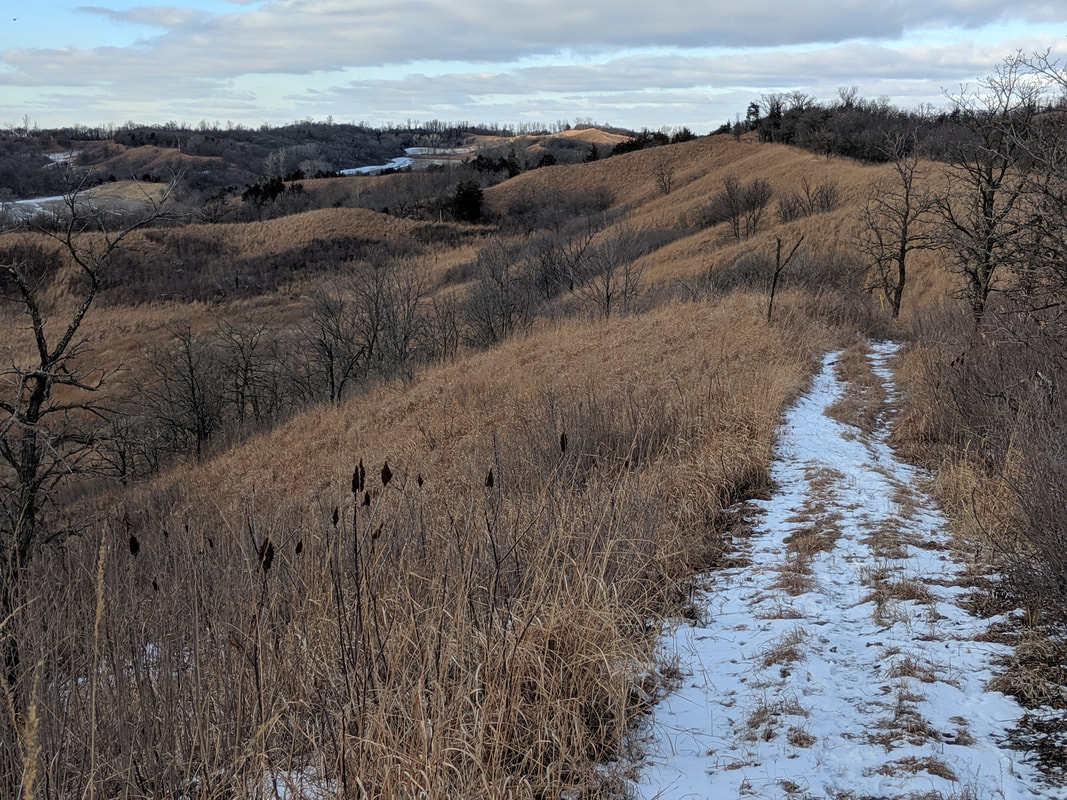 View from the Ridge Trail. Photo by Seth Brooks  View from the Ridge Trail. photo by Seth Brooks  View from the Ridge Trail. photo by Seth Brooks  A dead cedar tree along Ridge Trail. photo by Seth Brooks After two miles, the trail descends from the ridge through some trees to County Highway E60 and, after crossing the road, climbs to reach a clearing. Your initial instinct is to follow the ridge on your right heading south. Instead, continue ahead through a broad prairie heading due northeast. The trail bends southeast and becomes less open. Eventually, you will reach a confusing intersection. Don’t take the hard right that descends to the cornfield. Also, resist the urge to continue straight on the wide path under trees; this leads to another cornfield on the eastern side of the ridge. You want to stay on top of the ridge, so look for a narrow footpath cut deep into the earth that climbs up onto the grassy ridge. This intersection sorely needs a trail marker to point hikers in the right direction. Once on top of the ridge, the trail comes and goes but the path is simple: continue atop the ridge heading southeast. The occasional Iowa DNR trail marker will confirm that you are on the right track. When you reach a deep roadcut in the ridge, the plan is the same: climb down, then back up to continue along the crest of the ridge heading southeast.  View from the Ridge Trail in the spring. photo by Lance Brisbois  View from Ridge Trail in the fall. Photo by Lance Brisbois  View from Ridge Trail in the fall. Photo by Lance Brisbois  View along Ridge Trail. Photo by Seth Brooks View along Ridge Trail. Photo by Seth Brooks Eventually, the prairie is overtaken by eastern redcedar on both sides of the ridge. This forested section is an excellent spot to encounter wildlife. In December 2020, as I stopped along this section to check the Iowa DNR map and my GPS location, I heard a rustling in the woods on the eastern slope. I continued to look down until, from out of the redcedars, bounded a large whitetail deer with majestic antlers. The buck stopped in the middle of the trail, a mere twenty yards from me. We made eye contact, and before I could snap a photograph, it snorted and galloped down the western slope through the dense redcedar forest. Later, in January, dozens of turkey vultures took flight from the redcedar tops as I walked along the trail below. The trail descends under the canopy of the trees until it reaches a cornfield. Head southwest toward a gravel road, following it to reach a gate and a small parking turnout off County Highway E60. Cross the road with Jones Creek Pond ahead of you, staying on the trail on the eastern side of the pond.  Cedar canopy along part of the trail. photo by Lance Brisbois Before you return to the shelter and parking area, look for signs of a busy beaver or groundhog that has gnawed several trees to stumps. If you didn’t bring a picnic, two good places to stop for food or refreshment in nearby Pisgah are Dave’s Old Home Cafe or Sportsman Bar, the latter located in the same building as Loess Hills Country Corner. Pisgah is also home to the Loess Hills State Forest Visitor Center, an excellent source of information on the state forest and Loess Hills in general.  Loess Hills exhibit at Brent Olson Visitor Center in Pisgah. Photo by Lance Brisbois  Loess Hills exhibit at Brent Olson Visitor Center in Pisgah. Photo by Lance Brisbois More info & resources: |
Archives
June 2024
Categories
All
|


 RSS Feed