 Our mission at Golden Hills RC&D is to collaboratively develop and lead community, conservation, and cultural initiatives to improve our quality of life in rural western Iowa. Our "official" territory from our original organizational bylaws is an eight-county region in the southwestern portion of Iowa (Cass, Fremont, Harrison, Mills, Montgomery, Page, Pottawattamie, and Shelby). In 2023, we added four more counties (Audubon, Carroll, Crawford, and Monona). Several projects extend beyond these 12 counties into more than 20 counties (learn more about where we work).  Our goals are to develop industries in local communities that utilize local resources; ensure healthy natural resources that meet the needs of agriculture, industry, private use, and recreational facilities; promote and enhance art, culture and historic resources in rural communities; collaborate with local governments and organizations on projects that benefit the environment; and work on projects that fill gaps in community services to benefit people of southwest Iowa. We accomplish these goals by focusing our work in five program areas: outdoor recreation and tourism, land stewardship, water resources, local foods, and arts and culture. Today's Mission Monday focus is Arts & Culture.  Since 2018, Golden Hills has worked with Waubonsie State Park and Friends of Waubonsie State Park to host Iowa's first State Park Artist Residency program. This program is modeled after similar artist residencies at national parks and state parks outside of Iowa and was the first of its kind at an Iowa state park. Following Waubonsie State Park’s Artist in Residence program’s successful inaugural year, the Iowa DNR launched their “20 Artists, 20 Parks”, a similar program with faculty and graduate students from Iowa State University. This year, the Waubonsie State Park Artist in Residence program will award one residency that will take place from June 14th to 28th. Artists may work in a variety of media. The program was designed to allow artists a respite from their typical distractions so that they could intensively focus on their work in the quiet seclusion of Waubonsie State Park, while finding inspiration in the beauty of their natural surroundings. In exchange for the facility use during the residency, participants are required to perform public engagement either in person or through social media and to donate one piece of art to the park at the conclusion of their stay. Waubonsie State Park is a 2,000-acre preserve in the scenic and unique Loess Hills landform. The park offers many miles of hiking, equestrian, and bike trails through woodlands, prairies, and oak savanna. Waubonsie is located on the Loess Hills National Scenic Byway™ near Hamburg, IA, about an hour’s drive from Omaha and Lincoln, two hours from Kansas City, and two and a half hours from Des Moines. Golden Hills RC&D, Waubonsie State Park, and Friends of Waubonsie State Park are excited to announce the opening of the latest round of an innovative artist in residence program at Waubonsie State Park. This is the fifth season that the park will host artists for the program, which was the first of its kind in the state. Artists will receive living and studio space in the park, with time to focus on their work and seek inspiration from the southern Loess Hills. Applications are being accepted from Feburary 20th through March 31st. Artists will be selected through a competitive application process and notified by May 1st. The program is open to artists of multiple disciplines and from any location. For more details about the timeline and how to apply, visit www.goldenhillsrcd.org/artist-in-residence. 
0 Comments

Surging glacial meltwaters carved deep into soft glacial drift to form the middle Little Sioux River valley. Today, steep, unplowed prairie-cloaked hills flank this meandering river and forested and farmed valley. Glacial Trail Scenic Byway showcases this unique landscape. Nature, scenery, archaeology, and history intersect in the Glacial Trail Byway corridor, creating a compelling experience for byway travelers. This 36-mile corridor encompasses a landscape like no other in the region.
While you can drive the Glacial Trail Scenic Byway in less than one hour, there is a multitude of places to stop on or near the byway. Here is a list of six bucket list things to do on the Glacial Trail Scenic Byway.
1. Paddle the Inkpaduta Canoe Trail
The Inkpaduta Canoe Trail on the Little Sioux River runs from Spencer in Clay County to Smithland in southern Woodbury County. This span of river is approximately 134 miles in length.
The Cherokee County Conservation Board maintains 12 river access areas from the northern county border to the southern. These various access points permit paddlers to experience a relaxing 1-4 hour float or to escape for a camping and floating adventure over 3 or more days. Contact Cherokee County Conservation Board to rent canoes and kayaks. They rent a canoe/kayak trailer and all of the equipment for $200 per event. Trailer and equipment should be used within county or surrounding area. Individual canoes and kayaks are not available for rent. 2. Fish at Linn Grove Dam
Located in historic Linn Grove, Linn Grove Dam Area features a low-head dam on the Little Sioux River, making it one of the best fishing holes in Iowa. Four primitive campsites are located close to the river for great access and a bait shop that is open seasonally is located nearby.
3. See the bison at Prairie Heritage Center
The purpose of the Prairie Heritage Center is to provide environmental education as it relates to the prairie and the county, to preserve and protect our prairie heritage, and to encourage economic development with regards to recreation and historic exploration. Every season of the year is a great one on the prairie!
The Prairie Heritage Center opened its doors to the public on November 28, 2006. Over 100,000 people have visited the center since that time. They have come from all 50 states and over 26 foreign countries. It is a great place to enjoy educational and interactive displays, hike the trails, savor the wildflowers, and engage in bird and wildlife watching. Visit the Prairie Heritage Center and check out all the things to do! 4. Visit the Sanford Museum & Planetarium
Located in Cherokee, the Sanford Museum and Planetarium has exhibits and activities on a variety of subjects including: Archaeology, Art, Astronomy, Geology, History, Natural History, and Paleontology.
The museum was made possible through a trust fund established by the late Mr. & Mrs. W.A. Sanford of Cherokee, in memory of their only son, Tiel. It was their intention to create a charitable trust for historical, cultural and educational purposes that was to be free and open to the public. The facility was officially opened to the public in 1951. Since then, more than one million visitors have viewed exhibits, attended demonstrations, and taken part in a wide variety of activities. Sanford Museum & Planetarium 117 E Willow St. Cherokee, IA 51012 5. Birdwatching at Wanata Park
Wanata Park is a wonderfully quiet spot along the riparian habitat of the Little Sioux River just south of Peterson, Iowa. A great place for hiking and bird watching as well as other family recreation.

6. Find native wildflowers at Waterman Prairie
Waterman Prairie contains an abundance of unique native prairie habitat. Little Bluestem prairies are dotted with several colorful milkweed species, Pasqueflower, Prairie Moonwort, Purple Prairie Clover, Ground Plum, Prairie Blazing Star, Silky Aster, White Lady’s Slipper, and many native sedges. Oak savanna, one of Iowa’s most unique and threatened ecosystems, is characterized by prairie plants such as Side-oats Grama, Wild Indigo, and Prairie Phlox, interspersed with sprawling Bur Oaks.

 Our mission at Golden Hills RC&D is to collaboratively develop and lead community, conservation, and cultural initiatives to improve our quality of life in rural western Iowa. Our "official" territory from our original organizational bylaws is an eight-county region in the southwestern portion of Iowa (Cass, Fremont, Harrison, Mills, Montgomery, Page, Pottawattamie, and Shelby). In 2023, we added four more counties (Audubon, Carroll, Crawford, and Monona). Several projects extend beyond these 12 counties into more than 20 counties (learn more about where we work). Our goals are to develop industries in local communities that utilize local resources; ensure healthy natural resources that meet the needs of agriculture, industry, private use, and recreational facilities; promote and enhance art, culture and historic resources in rural communities; collaborate with local governments and organizations on projects that benefit the environment; and work on projects that fill gaps in community services to benefit people of southwest Iowa. We accomplish these goals by focusing our work in five program areas: outdoor recreation and tourism, land stewardship, water resources, local foods, and arts and culture. Today's Mission Monday focus is Outdoor Recreation & Tourism.  Golden Hills RC&D partnered with the Monona County Historic Preservation Commission to design four interpretive panels about historic sites in Monona County. The project was funded thanks to a grant award from the Monona County Community Partners Foundation. The Monona County Historic Preservation Commission was established in 1988 by the Monona County Supervisors. Their mission is to promote the educational, cultural, economic, and general welfare of the public through the recognition, enhancement, and perpetuation of sites and districts of historical and cultural significance. The Commission leads the Country School Experience, historic excursions for the Loess Hills Prairie Seminar, historic tours of the Mann School and South Jordan Township Cemetery by appointment, and have completed a brochure about the Turin Man. Their volunteers also assist with services for Memorial Day at the Ingemann Danish Lutheran Church and services for Memorial Day and the month of June at the Soldier Lutheran South Church. The group is all-volunteer and has a very modest annual budget of only $500. They work to keep history alive by collaborating with other groups on projects like this to educate residents and visitors about the rich history of Monona County. The panels will be installed at each of the four locations once the weather warms. All four sites are located near each other and would make an excellent weekend excursion to learn about the cultural history of Monona County.    
The Glacial Trail Scenic Byway is a 36-mile loop drive that takes some surprising turns through O'Brien, Clay, Buena Vista and Cherokee counties and the rural towns of Peterson and Linn Grove.
Traveling through the corners of these four counties, the byway boasts more than its share of parks and wildlife areas. Some are rich with cultural history and natural resources. Visitors will find park structures built during the Civilian Conservation Corps era and log cabins from pioneer days. Surging glacial meltwaters carved deep into soft glacial drift to form the middle Little Sioux River valley. Today, steep, unplowed prairie-cloaked hills flank this meandering river and forested and farmed valley. Glacial Trail Scenic Byway showcases this unique landscape. Nature, scenery, archaeology, and history intersect in the Glacial Trail Byway corridor, creating a compelling experience for byway travelers. 
Click the image to sign up for the Iowa Byways Passpot
The Iowa Scenic Byway Passport is new this year with an emphasis on Local Legends and fun new prizes, including limited edition Local Legend collectable cards. Now you can enjoy the beauty of Iowa’s scenic byways while learning about the history, people and places along the byways. Who knows, you might even become a Legend yourself!
It’s free to sign up and the more locations along the byways you visit, the more points you earn. Earn enough points and you can use them to secure a packet of 14 limited edition Local Legend Trading Cards.
During the month of February, travelers on the Glacial Trail Scenic Byway can pick up a free poster of the byway featuring its iconic bison. Stop at the Prairie Heritage Center near Peterson or the Sanford Museum in Cherokee, show your Byways Passport on your phone, and you will receive a free Glacial Trail Scenic Byway poster!
Make sure you also stop at the five Local Legends locations on the byway. Check in at each site to earn points. Those points can be redeemed for a set of 14 collectible cards featuring Local Legends from all 14 of Iowa's scenic byways. The five Local Legends locations on the Glacial Trail Scenic Byway are listed below. 
 Our mission at Golden Hills RC&D is to collaboratively develop and lead community, conservation, and cultural initiatives to improve our quality of life in rural western Iowa. Our "official" territory from our original organizational bylaws is an eight-county region in the southwestern portion of Iowa (Cass, Fremont, Harrison, Mills, Montgomery, Page, Pottawattamie, and Shelby). In 2023, we added four more counties (Audubon, Carroll, Crawford, and Monona). Several projects extend beyond these 12 counties into more than 20 counties (learn more about where we work). Our goals are to develop industries in local communities that utilize local resources; ensure healthy natural resources that meet the needs of agriculture, industry, private use, and recreational facilities; promote and enhance art, culture and historic resources in rural communities; collaborate with local governments and organizations on projects that benefit the environment; and work on projects that fill gaps in community services to benefit people of southwest Iowa. We accomplish these goals by focusing our work in five program areas: outdoor recreation and tourism, land stewardship, water resources, local foods, and arts and culture. Today's Mission Monday focus is Land Stewardship.  Since 2021, Golden Hills has worked with Dr. Tom Rosburg of Drake University, Chris Benda with Southern Illinois University, and Dr. Cynthia Lane to host virtual programs about plant identification and ecology. Golden Hills is partnering with Dr. Tom Rosburg to host another series of virtual plant identification class series in early 2024!  ID and Ecology for Viola in Iowa Monday, February 12 7-830pm $15 (+Eventbrite fees) Register here ID and Ecology of Iowa Native Shrubs February 26 7:00-8:30pm $15 (+Eventbrite fees) Register here ID and Ecology of Elymus in Iowa March 11 7:00-8:30pm $15 (+Eventbrite fees) Register here ID for Invasive and Native Look-alike Plant Species in Iowa March 25 7:00-8:30pm $15 (+Eventbrite fees) Register here For more information about this year's classes, as well as a listing of previous year's classes and recordings, visit goldenhillsrcd.org/plantid.html While many people overlook soil as 'just dirt,' human life depends on healthy soils. Civilizations, in fact, came to fruition in tandem with cultivating soils for agricultural development. Soil degradation and erosion have also contributed to most civilizational collapses throughout world history. Healthy soils provide many benefits, including: •Regulating water, which can help reduce flooding and drought impacts and improve water quality •Sustaining plant and animal life needed to sustain our own lives and livelihoods •Cycling nutrients including carbon, nitrogen, and phosphorous (Source: NRCS). Across much of Iowa and the tallgrass prairie biome, we have lost half or more of our topsoil. Fortunately in recent decades, agricultural conservation practices have significantly reduced the rate of soil erosion, but soil health continues to suffer in many places. In hilly areas like western and southern Iowa, soil quality has decreased in recent years on the tops and sides of hills as topsoil has washed downhill with snowmelt and rainfall. Wind erosion also blows away topsoil, According to the 2021 article by Thaler, Larsen, and Yu, "The extent of soil loss across the US Corn Belt, "[D]egradation of soil quality by erosion reduces crop yields, which can result in food insecurity, conflict (3), and the decline of civilizations (4). Degradation of soils leads not only to economic losses for farmers but also a loss in ecosystem services (5), which alters the ability of soils to regulate hydrologic and biogeochemical cycles. Widespread use of synthetic fertilizers to enhance the function of degraded soils increases food production costs (6) and impairs water resources (7), which negatively impacts human health (8) and aquatic ecosystems (9)." Although it takes time, soil can be regenerated through a few fairly simple practices known as the soil health principles: •Maximizing Presence of Living Roots, •Minimizing Disturbance, •Maximizing Soil Cover, and •Maximizing Biodiversity  Image source: https://www.nrcs.usda.gov/conservation-basics/natural-resource-concerns/soils/soil-health Image source: https://www.nrcs.usda.gov/conservation-basics/natural-resource-concerns/soils/soil-health N0-till, cover crops, extended rotations, and incorporating livestock into the landscape are some of the of practices farmers can use to regenerate soils.
In the coming weeks and months, we'll be going into detail on these principles, and explore how a variety of conservation practices can be used to improve soil health. Golden Hills currently has a few projects working on regenerative practices, including RCPP, ALUS, and Underserved Farmer. If you are a farmer interested in these, feel free to contact us! Stay tuned here for additional information about soil health coming soon!  Farmer meetup at Flavor Country Farms Our mission at Golden Hills RC&D is to collaboratively develop and lead community, conservation, and cultural initiatives to improve our quality of life in rural western Iowa. Our "official" territory from our original organizational bylaws is an eight-county region in the southwestern portion of Iowa (Cass, Fremont, Harrison, Mills, Montgomery, Page, Pottawattamie, and Shelby). In 2023, we added four more counties (Audubon, Carroll, Crawford, and Monona). Several projects extend beyond these 12 counties into more than 20 counties (learn more about where we work).  Our goals are to develop industries in local communities that utilize local resources; ensure healthy natural resources that meet the needs of agriculture, industry, private use, and recreational facilities; promote and enhance art, culture and historic resources in rural communities; collaborate with local governments and organizations on projects that benefit the environment; and work on projects that fill gaps in community services to benefit people of southwest Iowa. We accomplish these goals by focusing our work in five program areas: outdoor recreation and tourism, land stewardship, water resources, local foods, and arts and culture. Today's Mission Monday focus is Local Foods.   Farmer meetup at Brun Ko Farm Both Integral and popular parts of our Local Foods program, the Featured Farm blog posts and Southwest Iowa Farmer Meetups are great ways to learn about local producers in southwest Iowa. Golden Hills has organized several farmer meetups over the past year, including Cottonwood Hill Farms in McClelland and Flavor Country Farms in Honey Creek, which specializes in mushrooms and microgreens. The farmer meetups are a great way to meet local food producers and others interested in local food farming in southwest Iowa. Farmer meetups are free and include a tour of the host farm or the facility where the meetup takes place, making the events an excellent way to socialize and network with others in the local foods scence. Fortunately, if you missed previous farmer meetups, Golden Hills has two farmer meetups scheduled over the next two weeks.   In addition to organizing farmer meetups, Golden Hills has featured a total of 17 southwest Iowa farms in our "Feature Farm" series. This series of blog posts highlights local food producers, farmers markets, and businesses throughout southwest Iowa. Sycamore Ridge Small Farm LLC One Farm Market 3 Bee Farms Duncan's Poultry Garden of Paradise Flavor County Farms Archer Aqua Farms Mud Ridge Ranch Brun Ko Farm Hidden Hollow Farm Junge Produce Cottonwood Hill Farms One Farm Long Walk Farm Ditmars Orchard & Vineyard Sown Local Foods Paradigm Pastures  Archer Aqua Farms  Paradigm Pastures  Brun Ko Farm  Long Walk Farm  Mud Ridge Ranch  Our mission at Golden Hills RC&D is to collaboratively develop and lead community, conservation, and cultural initiatives to improve our quality of life in rural western Iowa. Our "official" territory from our original organizational bylaws is an eight-county region in the southwestern portion of Iowa (Cass, Fremont, Harrison, Mills, Montgomery, Page, Pottawattamie, and Shelby). In 2023, we added four more counties (Audubon, Carroll, Crawford, and Monona). Several projects extend beyond these 12 counties into more than 20 counties (learn more about where we work).  Our goals are to develop industries in local communities that utilize local resources; ensure healthy natural resources that meet the needs of agriculture, industry, private use, and recreational facilities; promote and enhance art, culture and historic resources in rural communities; collaborate with local governments and organizations on projects that benefit the environment; and work on projects that fill gaps in community services to benefit people of southwest Iowa. We accomplish these goals by focusing our work in five program areas: outdoor recreation and tourism, land stewardship, water resources, local foods, and arts and culture. Today's Mission Monday focus is Outdoor Recreation & Tourism.   Photo by Lance Brisbois
Since its inauguration in 2019, Brent's Trail has become one of the most popular hiking trails in the state of Iowa. Here is a selection of articles about the trail:
The trail is the start of a proposed trail that will eventually connect the northern and southern ends of the State Forest. A southern extension was added in 2021, allowing hikers to extend their hike for an 11-mile trek. The idea for Brent’s Trail was modeled after other long-distance trails such as the Appalachian Trail and Pacific Crest Trail. While we don’t have mountains in Iowa, we do have the Loess Hills. The Loess Hills are a geologically and ecologically significant part of Iowa’s landscape. Although loess soils are found in many places, the only place in the world with deeper and more expansive loess deposits are in the Yellow River Valley in China.  Photo by Lance Brisbois The Loess Hills in Iowa span 7 counties and roughly 200 miles. Nearby areas of the Loess Hills in Harrison and Monona Counties were designated as National Natural Landmarks by the National Park Service, one of only 7 in Iowa. The Loess Hills have many great opportunities for hiking, but until Brent’s Trail there wasn’t a point-to-point trail of significant distance. Iowa also has many multi-use trails of longer distances, but most are built on former railroad corridors or road right of ways, which means that they are relatively flat. Those looking for a rigorous, more challenging hiking experience were previously limited to isolated areas with a few loop trails. This trail, and its expansion, represent a completely new type of trail for Iowa. Longtime state forester Brent Olson had a vision for this type of trail many years ago. With the tracts of land owned by the Harrison County Conservation Board and the Iowa Department of Natural Resources through the Loess Hills State Forest, Preparation Canyon State Park, and wildlife management areas, there was the possibility for many miles of ridgetop trail.  Photo by Lance Brisbois However, to connect these areas there was a ‘missing piece’ between Harrison County Conservation Board’s Murray Hill and the DNR’s Loess Hills State Forest. Negotiations for access to that property had been at an impasse for years, and it seemed probable that the trail may never happen. With the development of the Loess Hills Missouri River Region Parks to People Plan, the idea of an Appalachian-trail type ridgetop hiking trail resurfaced. Ignited with a new vigor, the Iowa DNR pursued the possibility of an easement on the property – this time with success! Harrison County Conservation Board and the Iowa DNR put in countless hours preparing the trail. Trail markers, rustic steel cut into the shape of bur oak leaves, were made by a local artisan in Woodbine and the costs were covered by a grant from the Dean J. King Family Foundation.  Fountainbleu Loop on the Loess Hills National Scenic Byway (© 2016 Kenneth West) Brent’s Trail is located on the Loess Hills National Scenic Byway’s Fountainbleau Loop. Fountainbleau is the name of the cemetery where French-American fur trader Charles Larpenteur is buried. Brent’s Trail intentionally passes right by this cemetery. Murray Hill Scenic Overlook and Preparation Canyon Scenic Overlook are always highly recommended for those looking to get an iconic photo of the Loess Hills, and with the addition of Brent’s Trail visitors will be able to ‘get off the beaten path’ and further explore the unique landscape.  Photo by Lance Brisbois Brent's Trail is open to the public daily, year-round. Hikers should note that this is a rugged hike on dirt and grass surfaces. Water and restrooms are not available, so hikers should come prepared for a true backcountry experience unlike anything else in Iowa. The route is marked with metal oak leaf signs.  Photo by Lance Brisbois 
Brent's Trail in Harrison County (photo by Lance Brisbois)
New Year's Day was celebrated by many who took a hike on the Iowa side. First Day Hikes were held at several parks in western Iowa: more than 40 people hiked the canyon and forest trails at Preparation Canyon State Park in Monona County; more than 150 people joined park staff on a two-mile hike at Waubonsie State Park in Fremont County; and a great group hiked the trails at Prairie Rose State Park in Shelby County.

Hikers exploring Preparation Canyon State Park on the First Day Hike
Hiking and walking are excellent ways to get outdoors. The Loess Hills Missouri River Region has many miles of beautiful public hiking and walking trails. The WanderLoess Backcountry Hikes page includes some of the more rugged and longer hikes in Harrison, Mills, and Pottawattamie counties. Golden Hills RC&D has also developed an online Loess Hills Hiking Guide with a map of places to hike throughout the seven-county Loess Hills region. This list expands on that and includes hiking trails and walking paths for all ages and abilities in the Loess Hills Missouri River region. Is your favorite hiking or walking trail missing? Let us know!
However, don't think that the only hiking trails in western Iowa are in the Loess Hills! There are many great public areas in counties outside the Loess Hills that offer quiet and tranquil trails to explore any season of the year. Whiterock Conservancy in Guthrie County is celebrating its 20th anniversary this year. For more hiking locations throughout western Iowa, check out our series about hiking the three scenic byways that Golden Hills coordinates in western Iowa: Glacial Trail Scenic Byway, Loess Hills National Scenic Byway, and Western Skies Scenic Byway.
For specific trail recommendations, we have you covered too!
If you like to take your canine companion hiking, make sure you know about the rules and regulations of the public area where you intend to hike. Check out our blog post Hiking with Dogs in Western Iowa for more information. 
Dogs on leashes are allowed at Hitchcock Nature Center (photo by Seth Brooks)
Other hiking resources to check out: The Iowa by Trail app includes hiking trails across Iowa. REI’s Hiking Project has info about hiking trails nationwide. AllTrails has maps and reviews of hundreds of trails in the state. The book Hiking Iowa has more detailed summaries of some of the best hikes across the state (look for the second edition by Golden Hills' Seth Brooks in July 2024).

The second edition of Hiking Iowa will be released in July 2024
Do some research before heading out, as nature centers, restrooms, campgrounds, and other public facilities may have reduced seasonal hours. Come prepared with snacks and water. Stay on trails and obey private property boundaries. Only take dogs where they are allowed, keep them on a leash, and pack out their waste. Take a bag to carry out any of your trash, too. Stay safe, and take a hike!
Arrowhead Park - Hiking trails wind through wooded hillsides around a beautiful pond popular for fishing and paddling. Arrowhead Park trails map.
Botna Bend Park - Best known for live elk and bison, Botna Bend includes nature trails through prairies and woods along the West Nishnabotna River in Hancock. Botna Bend map. 
Nishnabotna Rock Cut Trail at Cold Springs Park in Cass County (photo by Seth Brooks)
Cold Springs Park - This 140-acre park is located south of Lewis, about 10 miles south of Atlantic. The highlight is the 0.7-mile Nishnabotna Rock Cut Trail (1.5 miles roundtrip) that leads to an unusual limestone outcropping on the East Nishnabotna River.
Council Bluffs trails - More than 40 miles of mostly-flat, paved trails connect the Missouri riverfront with Big Lake Park, Lake Manawa State Park, and much more. Council Bluffs trail map. Desoto National Wildlife Refuge - This refuge includes hiking trails through a large wildlife refuge along the Missouri River. It’s a great place to see wildlife, especially waterfowl and other birds. Desoto refuge brochure & map. Edgington Memorial Park, Avoca - Over a mile of paved, flat trails loop through this city park, along and across the East Branch of the West Nishnabotna River. Trails also connect into nearby neighborhoods. Map of Avoca trails. 
DeSoto National Wildlife Refuge in Harrison County (photo by Lance Brisbois)
Fairmount Park - Fairmount is a hidden gem in the middle of the metro. This city park has a few miles of rugged hiking trails through wooded Loess Hills with scattered prairies and restored oak savanna overlooking Council Bluffs and the Omaha skyline. Map to Fairmount Park.
Folsom Point Preserve - Owned and managed by The Nature Conservancy, this nearly-300 acre area features beautiful remnant prairies overlooking the Missouri River valley just minutes from Council Bluffs and Omaha. Hiking paths lead from the parking area to the ridgetop. Map to Folsom Point. 
Folsom Point Preserve in Mills County (photo by Seth Brooks)
Glenwood Archaeological State Preserve - Located just outside Glenwood, the 900-acre preserve includes paved trails through woods and prairies. Formerly known as Foothills Park, the site is known to have numerous archaeological sites from the prehistoric Glenwood culture. Map to the Glenwood preserve.
Harrison County Welcome Center - In addition to an Iowa Welcome Center and historical village complex, this welcome center just outside Missouri Valley. Welcome Center map. 
Hitchcock Nature Center (photo by Seth Brooks)
Hitchcock Nature Center is Pottawattamie County’s premier hiking destination located near Honey Creek. It has 10 miles of trails through Loess Hills prairies, woodlands and savanna. Hitchcock trail map.
Lewis & Clark Monument Park - With five miles of trails over 80 acres, this Council Bluffs city park features commanding views of the Missouri River, Council Bluffs, and downtown Omaha. The trails are also popular for mountain biking. Lewis & Clark park trail map. Loess Hills State Forest (LHSF) & Preparation Canyon State Park - The state forest and park encompass nearly 12,000 acres over four units in Harrison and Monona counties, with dozens of miles of hiking-only trails.

Loess Hills State Forest (photo by Seth Brooks)
Mile Hill Lake - This park is located along Highway 34 near Glenwood and includes hiking paths through woods, prairies, and a marsh. The lake is popular for fishing and paddling. Map to Mile Hill Lake.
Milliman Park - Logan city park with a short hiking trail. Milliman Park trail map. Oakland City Parks - Oakland has three city parks with popular walking trails. Chautauqua Park includes flat, paved trails near the West Nishnabotna River. Map to Chautauqua Park. Old Town Conservation Area - This area has about 10 miles of hiking trails through prairies and woodlands overlooking the Boyer and Missouri river valleys as well as the community of Missouri Valley. Old Town trail map. 
Old Town Conservation Area in Harrison County (photo by Lance Brisbois)
Pleasant View Park - Dunlap city park with short, ADA-accessible walking trail around a smal pond. Pleasant View Park trail map.
Pony Creek Nature Center - Pony Creek features a popular lake, nature center, campgrounds, and rugged Loess Hills hiking trails through woods and prairies. Map to Pony Creek. Ray Thomas Wildlife Preserve - Mills County Conservation Board’s Ray Thomas Preserve in has a mowed walking path through woodlands and restored prairies in eastern Mills County. Map to Ray Thomas preserve. Rock Island Old Stone Arch Nature Trail - This paved trail located primarily in Shelby County extends just into Pottawattamie County with a trailhead near the Shelby exit on Interstate 80. The trail runs west through woods, prairies, wetlands, and creeks and crosses Silver Creek on an historic Stone Arch Bridge. Map to trailhead. Sawmill Hollow Wildlife Area - Known best for a popular fishing hole, Sawmill Hollow has 155 acres of wooded Loess Hills and ridgetop prairie to explore. Sawmill Hollow map. 
Vincent Bluff State Preserve in Council Bluffs (photo by Lance Brisbois)
Schaben Park - Located near Dunlap in northeastern Harrison County, hiking trails surround a small pond through oak woodlands. Schaben Park trail map.
Smith Wildlife Area - This little-known wildlife area includes 175 wooded acres located immediately outside of Council Bluffs and is open to hiking throughout. Map to Smith Wildlife Area. Vincent Bluff State Preserve - A 42-acre remnant prairie in the middle of Council Bluffs with panoramic views of the city. A short footpath leads from the parking lot to the ridgetop. Map to Vincent Bluff. 
West Oak Forest in Mills County (photo by Lance Brisbois)
Wabash Trace Nature Trail - This crushed limestone trail follows a former railroad line from Council Bluffs to Mineola, Silver City, Malvern, and beyond. It’s also popular with bicyclists. Trailheads are located in each community. Wabash Trace trail map.
West Oak Forest - Hike up steep Loess Hills bluffs overlooking the Missouri River valley between Glenwood and Council Bluffs. More than three miles of trails through woodlands and remnant prairies. Map to West Oak Forest. 
Whiterock Conservancy in Guthrie County (photo by Seth Brooks)
Wheeler Grove Conservation Area - This 247-acre wildlife area in eastern Pottawattamie County has prairies, oak savanna, and woodlands to explore along Jordan Creek. Map to Wheeler Grove.
Whiterock Conservancy - Whiterock Conservancy is a 5,500 acre, nonprofit land trust with more than 40 miles of multi-use trails, which take hikers through savannas, rolling pastures, native and restored prairies, wetlands, riverside bluffs, and fishing ponds. While not in the Loess Hills, exploring this Guthrie County gem is worth the drive. Willow Lake Recreation Area - 220-acre park near Woodbine, including popular lake and campgrounds. Hiking trails wind through Loess Hills prairies and around the lake. Willow Lake map. Wilson Island Recreation Area - Adjacent to Desoto refuge, this 544-acre state-managed area has trails winding through floodplain woodlands near the Missouri River. Wilson Island trail map. In addition to all these great places, take a hike through your yard, farm, or neighborhood. Stop and listen to birds and other wildlife. Look for wildflowers, mosses, and lichens. You’ll be amazed at how much there is to see and do right here in our region! 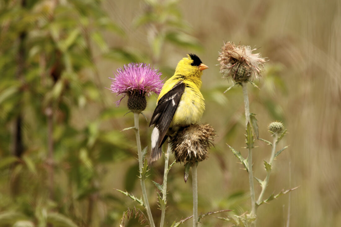
American Goldfinch at Loess Hills State Forest (photo by Carter Oliver)

|
Archives
June 2024
Categories
All
|


 RSS Feed